
Cruising north along the Santa Barbara coast can be smooth sailing across sheltered waters, with the majestic backdrop of the Santa Ynez Mountains towering above expansive kelp beds and calm sandy beaches. As you get close to Point Conception, however, wise mariners know that smooth sailing can simply be the calm before the storm.

map by CDFW Marine Region GIS Lab
Point Conception is a rocky point that juts westward into the Santa Barbara Channel and provides a geographic separation between southern California waters and the more windswept, turbulent central California coast. Many ships have been lost or turned back by strong winds while attempting to pass the point, where wind and current amplify the waves. In fact, the first records of Point Conception from early European explorers were of failed attempts to round the point, collisions with rocky reefs, and ships being blown out to sea. Point Conception is known as Humqaq to the Native American Chumash people, who regarded it as the sacred western gate to the afterlife. Bounded by private ranches and Vandenberg Air Force Base, Point Conception State Marine Reserve (SMR) is challenging to access from land and often difficult to access from sea. The remoteness of its location makes it one of the least-visited mainland marine protected areas (MPAs) along California’s south coast. Despite the challenges, the California Department of Fish and Wildlife (CDFW), in partnership with Marine Applied Research and Exploration (MARE), completed video surveys of the reserve and 10 other Southern California MPAs in 2014 using MARE’s remotely operated vehicle (ROV), the Beagle.

CDFW photo by M. Prall
CDFW has been exploring the deep water habitats off California’s coast and within MPAs since 1999. I was fortunate to lead a team performing ROV surveys at Point Conception SMR during a calm spell in January 2014. What we found was one of the strangest and most unique features I’ve witnessed during a long career of exploring underwater habitats: combinations of deep rocky reefs and natural petroleum deposits on the seafloor. Although not as spectacular and dramatic as some habitats, the marine life we found associated with the deposits at Point Conception SMR underscores the tenacity and diversity of marine life found in California’s nearshore waters.

CDFW Marine Region GIS Lab map
Although we were aware that natural petroleum deposits are common in the Santa Barbara Channel, and had experienced noxious fumes bubbling up from seeps along the coastline on our way to the area, the extent of these features within Point Conception SMR was surprising. Bumpy, dome-like features shown on sonar seafloor maps turned out to be uplifted mounds of tar with varying degrees of sediment and biological growth on their surface. These “tar mounds” are naturally occurring ancient deposits which have been slowly pushed to the surface by shifting tectonic plates in this geologically active area. The mounds varied in size from only a few yards across to very large mounds covering hundreds of yards. After closer examination of our findings, we determined the tar mounds cover nearly 1½ square miles of seafloor inside Point Conception SMR.

CDFW/MARE photo
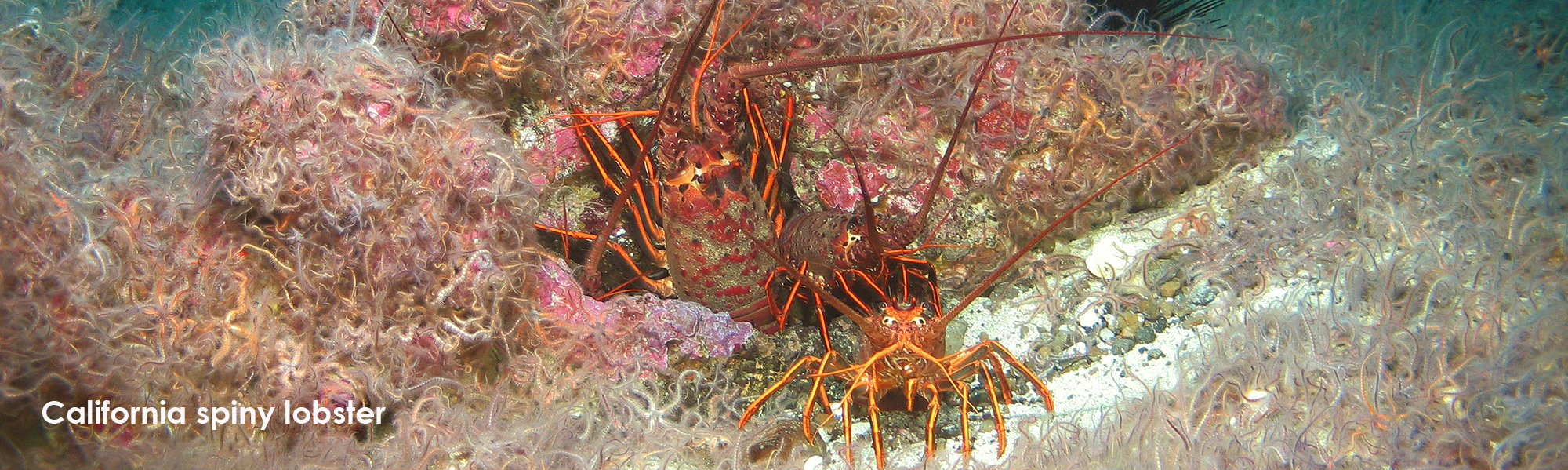
Most of the tar mounds are covered with a mixture of sand, gravel, and shell fragments, forming a hard surface similar to rocky reef areas, with invertebrate and algal growth on top. Red rock crabs were common in these areas along with Kellet’s whelk and some Dungeness crab in the sandy areas. We also saw a few areas of fresher, less viscous, flowing tar. These active tar mound areas had gas bubbles and tar breaking off, forming pointy whips as the lighter-than-water material stretched and floated away. Many small, unidentified red-orange snails were observed on this fresh tar, possibly eating bacterial or algal films. Even a few fish were seen hiding in small pockets formed by the rippled tar mound surface.

CDFW/MARE photo
I have explored the seafloor off the California coast using ROVs for 17 years as a marine biologist for CDFW. While I have seen many beautiful rocky reefs and vast stretches of barren sand and gravel, these tar mound habitats are one of the strangest and most unique features I’ve encountered. Not much is understood about how these natural deposits function in the marine ecosystem.
Although not as biologically diverse as rocky reefs, these areas provide habitat for many invertebrates and fish species. The unique combination of tar mounds and the marine life found on them add to the mystique of this hard-to-reach location. Point Conception SMR protects these habitats along with areas of kelp beds, rocky reef, and deep, soft seafloor. Hopefully our surveys will inspire future study of this unique combination of marine habitats.
Point Conception State Marine Reserve is one of the 124 MPAs in California’s statewide MPA Network. Please visit CDFW’s MPA website for more information, and sign up to receive updates about the MPA Management Program.
post by CDFW Environmental Scientist Michael Prall
Learn more about MPAs by diving into the Exploring California’s Marine Protected Areas series!
